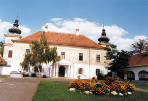
The small town is situated in the heart of county Pest, 26 km from Ferihegy Airport Budapest, along main road No. 4. As it is situated in the area where the Gödöllő-Ceglédbercel hills meet the sandy ridge of the Danube-Tisza area, it is surrounded by hills and deep valleys with gullets in the north, while in the south you can enjoy the beauty of the Great Hungarian Plain. Today it has nearly 12,000 inhabitants.
In the central part of the Pilis hills you can find the brook Gerje and its region of source with lakes, shady groves and protected natural values, which all provide excellent excursion spots. The territory was inhabited as early as the Bronze and the Iron ages and later in the period of the Hungarian conquest. The area is rich in archaeological findings. It was first mentioned in records in 1326. At that time the Holy Spirit church used to stand here, which is shown by a memorial place today. Another important monument is the beautifully restored Baroque Lutheran church from the 1700s, which has the largest Lutheran congregation in the country today. Viniculture and viticulture have long traditions here, the light wines of the sandy region are grown in the vineyards in the south and in the east. Apart from the small and large vineyards with press houses and cellars, in the north you can find the Hegyeki row of cellars with friendly atmosphere, which was hollowed out in the loess walls of Dolina. The corridor motorway 4 is to be built in the future, which will be the most modern transit road in the country.
